Guest Post: by Matthew Davidson, P.Ag., AScT., EP
Environmental Scientist
Valhalla Environmental Consulting Inc.
As an environmental consultant, I work in a field that depends on data. This may seem obvious, but when you think about it, you start to realize that the better the data quality, the better the opportunity to observe and interpret a given subject. Thus, we are always on the lookout for new ways to acquire high-quality data. Our firm has recently incorporated Unmanned Aerial Vehicle (UAV) technology into our operations to collect aerial imagery, near-infrared imagery, and Digital Terrain Surface (DTS) data.
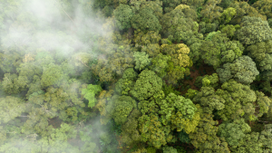
Aerial photography is a common data source for many environmental practitioners. As a result of the budget, weather, and timing constraints of a project, it is often not feasible to collect aerial imagery via traditional aircraft. Technologies for acquiring aerial imagery are rapidly developing, allowing for the commercial application of UAVs. UAV technology (drones) was developed initially for military applications, but it has advanced to the point where it can be applied to environmental data collection as well.
UAVs are now being deployed to collect near-real-time imagery for use as aerial photos, near infra-red imagery and to generate 3D digital surface models. UAV technology has also enabled access to site-specific, near-real-time aerial imagery; data treatment options that complement and integrate into GIS and drafting systems; and cost-effective analysis methods that employ high-resolution imagery.
Since the flight path is GPS controlled, the operation can be precise and repeatable for seasonal or annual monitoring, updates or reporting.
Applications for this technology are broad. Fields, where this technology is immediately applicable, include mining and gravel extraction, agricultural monitoring, civil engineering and construction, planning and development, forestry, and transportation. The product is a site-specific, high-resolution image mosaic that is orthorectified and geo-referenced. The image mosaic can be acquired by full colour or near-infrared cameras depending on application and data requirements. Some data treatment examples include:
- The use of near-infrared imagery for producing Normalized Differential Vegetation Index (NDVI) maps, which represent direct measures of plant vigour. This technology is increasingly applied in viticulture and agriculture.
- The creation of 3-D surface models that can be generated for sites requiring volumetrics. This technique is increasingly applied in cut and fill applications.
The availability of up-to-date and repeatable UAV acquired aerial imagery will enable greater and more thorough desktop review and analysis of the project, research and monitoring locations. The cost-effectiveness and flexibility of the technology will permit the collection of aerial imagery data in projects that may not have previously had access to this type of information. Applications and uses of these technologies will only grow as UAVs evolve. Within environmental consulting, we can see the incorporation of this technology into environmental assessments, environmental monitoring, habitat restoration, forestry and wildfire, along with GIS modelling and mapping.
The environmental sector will benefit from the availability of up-to-date, site-specific, cost-effective and repeatable aerial image data collection. The images are available almost immediately after flight. The flexibility and manoeuvrability of the technology allow data to be collected from locations that are difficult to access, potentially dangerous and previously expensive to get to. Rather than relying on outdated imagery, a consultant, manager or researcher can now work with recent GIS capable data.
Resources
The commercial application of UAVs is regulated and monitored in Canada by Transport Canada. This ensures that UAVs are operated safely and that properly trained, experienced operators are at the controls.